Glossary A B C D E F G H I J K L M N O P Q R S T U V W X Y Z
Water Agencies
http://www.lesagencesdeleau.fr
Public State bodies, the aim of the water agencies is to help to improve water resource management and to protect aquatic environments in their river basin area. They are financed by taxes on abstraction and water pollution. The water agencies provide funding for common interest initiatives. Each agency focuses on a specific river basin district (see river basin district).

Water Body Drop
(See Pressure Drop)
A drop at one point on the body of the piezometric level, due to water abstraction from the groundwater body, a drop in the surface curve of a waterway which is linked to the body, or due to earthworks.
Water Framework Directive (WFD)
Directive 2000/60/EC of the European Parliament and Council of 23rd October 2000, establishing a framework for a Community water policy, commonly known as the “Framework Directive”.
The WFD sets objectives and timescales, including obtaining “good water status” by 2015, and sets out a procedure for achieving these targets and deadlines: making an inventory, defining a surveillance monitoring programme, public consultation and participation in the drawing-up of river basin management plans, adoption of a programme of measures, recovering costs etc.
Water Framework Directive District
A land and maritime area made up of one or more river basins as well as the associated groundwater and coastal waters, identified by the WFD as the main water management unit. An inventory, surveillance monitoring programme, management programme (revised Blueprint for Water Development and Management) and a programme of measures must be established for each district.
Water Framework Directive River Basin
(See Water Framework Directive District)
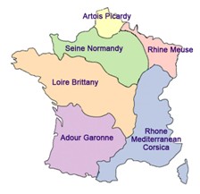
An administrative water development and management unit. France is divided into fourteen basins or basin groupings, with each one having a Basin Committee, a monitoring programme, a Blueprint for Water Development and Management, and a programme of measures applying the WFD.
Water Level
The height of the surface of unconfined water above a reference level (vertical distance between the surface of a waterway, lake, reservoir (or a groundwater observation well) and gauge zero).
Water Point
A water point is a natural (spring) or artificial (borehole, drain, well) groundwater access point.
Each water point has a national code. This is the water point file code at the Underground Strata and Hydrometric Information Databank (see BSS Code). For information purposes, the national code may be supplemented by so-called “local” codes, namely the manager’s internal water point code, or the owner of the water point’s code.
Each water point is located using its geographic coordinates as part of a projection system and linked to the local area of the zone where it is situated.
It is defined by the following information:
- National water point code or BSS Code.
- Water point name or particulars.
- Water point altitude.
- Address - location of the water point.
- Water point location map.
- X and Y geographic coordinates of the water point.
- Type of projection of the water point’s geographic coordinates.
Water Quality Analysis for Public Health Purposes
Tests carried out on all water destined for different forms of use which affect public health (drinking water, bathing water, watering), and which check that the water complies with consumption, public and animal health regulations (WHO standards etc). Sampling points and the benchmark analytical methods used for these tests are determined by the relevant national authorities (Ministry of Health, Ministry of Agriculture etc.)
Water Status Surveillance Monitoring Programme
The WFD set of monitoring measures at river basin district level, enabling a coherent and full picture of water status to be drawn up. This programme includes:
(* Monitoring checks in order to evaluate the impact of human activity on water bodies and long-term changes in the status of water bodies.
- Operational checks aiming to evaluate the status and evolution of water bodies which are at risk of not achieving the environmental objectives.
- Tests aiming to identify the origin of a deterioration in water status.
The monitoring programme should be operational at the end of 2006.
Water Supply
(see Groundwater Recharge)
Water Table
The first body of groundwater encountered when digging a well. A generally unconfined body, i.e. the surface is subject to atmospheric pressure. The body can also be pressurised if the covering land is not very permeable. When unconfined, it moves around in an aquifer including an unsaturated zone close to ground level.


